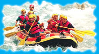
Rafting
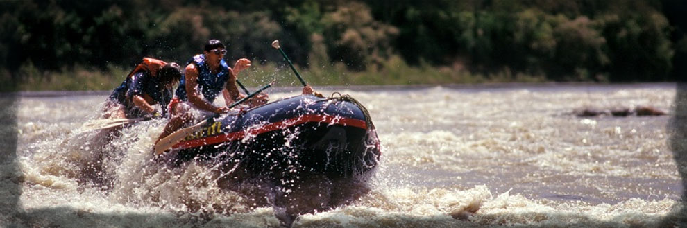
The challenge of a turbulent river is no less than that of the rugged mountains. The icy heights of the Himalayas are the source of some of India's mighty rivers. Fed by innumerable streams they race along tortuous boulder strewn beds, cutting deep gorges and breaking into silvery white rapids. The term 'White water' refers to foamy and whitish appearance of fast flowing water. The white water river rafting is quite thrilling and adventurous. With the intricate network of mountain rivers flowing through a myriad of different colors of rocky Gorges, forests, flowers and high mountain villages, the hills provide ideal locals for the perfect water adventure.
The sport of white water river rafting calls for a triumph over the swift, swirling river as it gushes past spectacular mountains. It is practiced mainly in the upper reaches where the water is wild and white as it froths and foams, crashing against narrow gorges, rocky outcrops and falls at deep gradients. The suitable period for river running depends on the adequacy of water volume. Thus September - November and March - April - May are most appropriate. The equipment required is ordinary outdoor gear, goggles, antiseptic cream and a liking for getting wet.
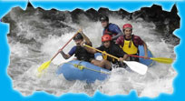
Man is always dreaming up of new adventures. River rafting is another adventurous sport, which has been practiced by men through years. Rafting is a white water sport. The term white water refers to foamy and whitish appearance of fast flowing water. During the past 15 years or so, Rubber Rafts, Canoes and Kayaks and other crafts, have run many of the great rivers in India. Apart from the logistic arrangements regarding the transportation of boats to the starting points and again at the end of the journey to transport them back there are no serious problems in river running. River running in the white waters is extremely thrilling but it can also be risky.
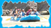
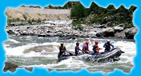
One of the great advantages of rafting is to travel leisurely through the varied terrain and enjoy interaction with the locals and take photographs. In river running each day could hold promise of new discoveries. Most travel agencies have included rafting in their trekking itineraries. They use the most modern unsinkable rubber rafts and have a set of reasonably trained river guides who have also developed some expertise in cooking and first aid.
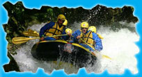
River running is usually organized early in the morning until mid or late afternoon when the camp is set up on some secluded area on the beach. Travel agencies have fairly good logistic support and delicious meals are cooked in the camp. River trips are generally safe and can be enjoyed by families and holidaymakers of all ages. It would be desirable to insure that the inflatable rubber rafts are of reasonably good quality and are specially meant for river running. Most rafts are specially outfitted for safety and are virtually unsinkable with an independently inflatable compartment. Each traveler is provided with a life jacket as well as waterproof kitbags for clothes and watertight boxes for cameras etc. A trained crew, arranged by travel agencies does the rowing of these rafts, and they usually confirm to international standards.
Deoprayag
Deoprayag is at a distance of 71 km from Rishikesh. The Bhagirathi from Gaumukh mingles with the river Alaknanda from Satopanth to form the sacred Ganga. Pilgrims bath in the Sangam and offer 'Pind' Shradha. At an altitude of 618 Mts. (2000 ft.) here are ancient temples of Raghunathji and Lord Shiva which are both landmarks as well as the Raghunath Kirti Mahavidyalaya, the headquarters of the pandas of the Badrinath.
The pandas of Sri Badrinath hail from this town. Most of the pandas are pandits who are scholarly and their knowledge of Sanskrit is a family inheritance. It is also linked with 30-km motorable road to Pauri. There is a P.W.D. Rest House, a Tourist Bungalow besides, and so many dharamsalas at Deoprayag.
Accessibility:
Rail: Neraest Railhead, Rishikesh 71 kms.
Road Rudraprayag is well connected by road with Dehradun, Haridwar and other places of Garhwal.
Kullu Valley
Kullu is situated at an altitude of 1200 Mts., it has an area of approx. 1.6 km wide and 80 km long Kullu is the district head quarters of the Valley.The Beas River flows in Kullu valley of Himachal Pradesh. Some basic rafting is available along the Beas River from May to mid-June, and depending on the monsoon. Kullu is reasonably set up with hotels and other facilities. Kullu is small enough to walk around. Kullu is famous for its shawls and other Handicrafts.
Kullu holds one of the most colorful Dussehra festivals in India. The Kullu valley has always been a popular place to hang out and take in some mountain scenery. The best time to visit Kullu is from April to June and from September to November.
Best Season:
April to June
Accessibility:
Air: Bhuntar airport is 10 km from Kullu town.
Road: Pathankot is almost 285 km by road and is linked
by direct trains from Amritsar, Delhi and Mumbai.
Kumaon
Kumaon occupies the easternmost part of the mountainous region. Three Districts constitute Kumaon viz. Almora, Nainital and Pithoragarh. Kumaon has a total geographical area of 21,035 sq. km. The altitudinal range of Kumaon varies from 200 Mts. in the terai and bhabar tract to over 7500 Mts. in the main Himalayas. Kumaon enjoys a varied climate. The winter season is perhaps the longest season in Kumaon i.e., from mid-Nov. till March. In Kumaon, the Kali Ganga (sharda) flows down from the Nepal border, through Kumaon Hills. It flows for a considerable distance along the border of Kumaon (India) and Nepal.
Accessibility:
Air: Nearest Air port is Pant Nagar, 62 kms.
Rail: Nearest Railway Station is15 kms away from Khatima.
Road: Distance from Nainital 119 kms

Ladakh
The mountains of Ladakh may not be as spectacular as some parts of the high Himalaya. Ladakh is a completely magical place, remote, with delightful, gentle, Ungrasping people. Ladakh also developed a very distinct culture. The temperature of Ladakh ranges from max. 29oC to min. -10oC. rainfall is only 50 mm annually. Sand Dunes dot the desert like lanscape in places and there are even occasional dust storms.Zanskar River originates from the high altitude plateau of Sarchu on the border of Himachal Pradesh and Jammu and Kashmir.
Ever since trouble broke out in the Kashmir valley, Ladakh has become a favorite tourist destination for many. During the 1st two weeks of September, the Ladakh Tourism Department organizes Ladakh Festival, and it is a not to be missed event. Ladakh offers a range of possibilities to the tourists and one visit is sure to have you asking for more.
Rafting Season : early July to mid September
Accessibility:
Air: June to September IA has daily return flights between Leh and Delhi.
Road: only two ovrland routes to Leh: the road from Srinagar, and the road from Manali in HP.
Manali
The modern town of Manali sits at the northern end of the Kullu valley. It is a pleasant town with lovely forests and orchards nearby for hiking and good facilities for visitors. It is one of the most popular places in the country for honeymooning, Indian couples.Manali means 'Home of Manu'. The best season to visit Manali is from April to June and then mid September to early November. It has an area of 5.12 sq. km. Manali is situated at an altitude of 2050 Mts.The climate of Manali is Very cold in winters and windy in summers. Best season to visit Manali is from April - June and September-October.River Spiti flows through Manali-Kullu Valley.
Best Season :
April to June Sep. to October
Accessibility:
Air: Bhuntar air port is 50 kms from Manali and 10 km beyond Kullu.
Road: Manali is 40 km fromKullu.
Rishikesh-Kaudiyala
Rishikesh is a great pilgrimage center of India, attracting a large number of pilgrims. It is situated on the Right Bank of river Ganga and is surrounded on three sides by Himalayan ranges. Rishikesh has an area of 11.20 sq. km. It is situated at an altitude of 356 Mts. The Yoga centers of Rishikesh have enhanced the significance of the place, home and foreign tourists from all over the world visit this place to have lessons in Yoga and meditation.
Kaudiyala
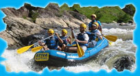
: Kaudiyala is located on the Rishikesh-Badrinath road at a distance of 36 kms. is situated at an altitude of 389 Mts. Here, the mighty waters of Ganga are ideal for white water rafting. Many river rafting courses are conducted at Kaudiyala. Kaudiyala is surrounded by dense forest. there is a great opportunity to view wildlife in its natural habitat. Nature walks along the river are a real treat, as you can see majestic wildlife. At Kaudiyala the river rafting courses are conducted throughout the year.
nearest railhead is Rishikesh. Buses and taxis are available from Rishikesh to Kaudiyal 37 kms.
80 kms from Dehraadun and 61 kms. from Haridwar.
Rafting Season : October to December February to June
Accessibility:
Air: Nearest airport is Jolly Grant which is 18 km. from Rishikesh on the way to Dehra Dun.
Rail: Rishikesh is connected by rail with Haridwar, Delhi, Mumbai, Howrah, Lucknow and Agra.
Road: Rishikesh is connected by road with most places of North India.
Rudraprayag
After proceeding to the Ganga valley to Deoprayag and along the Alaknanda to Srinagar, it reaches Rudraprayag, 34 km away and at an altitude of 610 Mts.(2000ft.).
The ancient Narad Muni meditated here for several years at the temple of Rudranath, so as to attain perfection in the science of music. Pleased with his devotion Shiva blessed Narad, granting him the cherished wish that the sage became the repositary of shastric music. Here, in the temple, Shiva is worshipped in the form of Rudranath. With a population of 5,000 Rudraprayag is at the junction of the three hill districts of Pauri, Tehri and Chamoli.
Accessibility:
Air: Nearest airport Jolly Grant, 159 kms.
Rail: Nearest Railhead, Rishikesh 142 kms.
Road: Rudraprayag is well connected by road with Rishikesh, Kotdwar, Dehradun and Haridwar